The Best Drone Apps: These air traffic controllers will help you
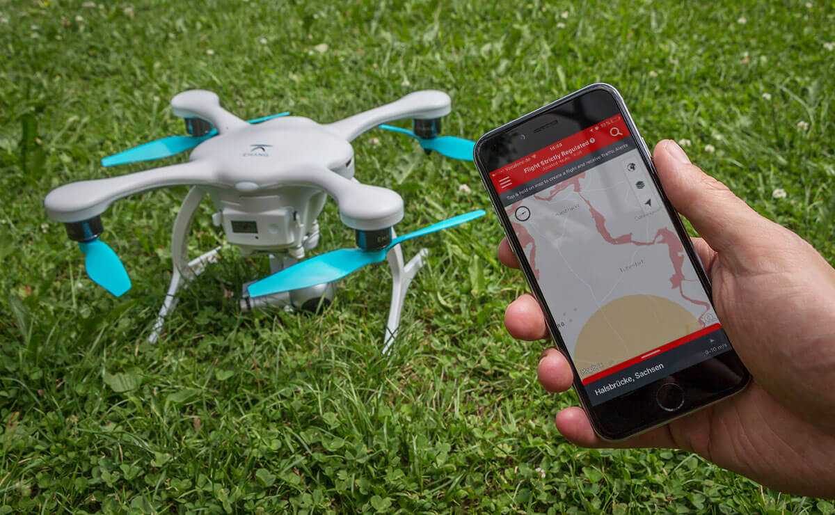
Apps for the smartphone can help us a lot when flying a drone. A look into a drone app should be part of every flight preparation. What the drones apps can do for us pilots and which apps are really recommendable, I describe in this article.
Meanwhile, there are countless offers in the app stores, which are aimed at drone pilots. Unfortunately, there are also many drone apps that offer very little added value or do not work at all. Later in the article, I’ll introduce you to the best apps that work really well.
At the beginning I would like to explain to you, what is especially important to me with a drone app.
What features a drone app should have
First of all, I want to be one map can see if I am allowed to fly at a certain position. Is there in this place Airspace restrictions? Is my desired location in a nature reserve? A good copter app should be able to answer such questions. I do not just use this feature just before I want to take off. Even when planning a flight, I include such information.
But one more important NOTE: You can not rely solely on the data in an app. Because of the new drones regulation many bans came into force in Germany, which are currently not considered by any app. Be sure to check out our drones rules article to independently check the environment for bans.
In addition to the map feature, there are a few more features that I want in a drone app:
- Log: With a logbook function you can document your flights and prove your experience as a drone pilot. As part of the logbook, I wish the following two functions:
- Administration of Copterns: We own several drones. Since it is useful if you can deposit different models in the logbook.
- Administration of pilots: During the flights, we both change every now and then. That’s why I think it’s great when you can manage the pilots in an app.
- Weather History: A forecast of the expected wind strength, temperature and precipitation is useful.
- KP Index: The KP index indicates the activity of the sun. A high KP index can cause problems during the drone flight (more about that you will learn in our copter camp). That’s why it’s great when the app points to a high CP index.
Now you know my claim to a good drone app. Some apps provide additional functions. So you can see whether other pilots already fly in a region to avoid collisions. But since this feature only brings something, if all pilots use the same app, I’m not relying on it at the moment. It is a useful additional information anyway.
Our recommendations: The best drone apps
Enough the preface, now I would like to introduce you to my favorite apps. I took my criteria and rated the apps accordingly.
 Recommendation 1: AirMap
AirMap is a drone app from the US, which now works very well in Germany. Since we travel a lot with our drone, this app is my favorite because I can use it worldwide. But AirMap is not only my favorite application because of its functionality – the design is also very appealing.
When I open AirMap, I get my environment displayed in a map in which flight restriction areas are color coded. As with a traffic light, I get immediately feedback on the colors green, yellow and red, whether I may fly at this position or not. With just one click / tab, you can see more information about restrictions. In addition, telephone numbers (for example to the tower of the nearest airport) are indicated. Unfortunately, the contact details are missing on many heliports.
Advantages of AirMap:
- Assessment of regional conditions with traffic light colors.
- In map various overlays (different airspaces, heliports etc.) can be displayed.
- Worldwide use of the app possible.
Disadvantages of AirMap:
- No recording possible for different pilots in the logbook.
- Current KP Index is not displayed.
AirMap on the App StoreAirMap on Google Play
 Recommendation 2: Kopter professional app
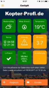
The well thought-out app of the Kopter Profi GmbH was reserved for a long time only the users, who had completed a copter insurance with the broker. Meanwhile, you can unlock the benefits of the app via an in-app purchase. This already works on Android smartphones. For iOS devices, however, this will soon be possible. If you want to get your own opinion of the app first, you can use a one-week free trial.
The app itself is very well structured. On the dashboard, you have all the information relevant to a flight (such as expected precipitation and wind, KP index, airspace query, etc.) vividly listed. The Kopter Profi app is noticeably geared to the German market, which offers a great advantage. Directly in the app you can see the telephone numbers of the police stations and the towers (air traffic control) in the immediate vicinity. This feature is unique to the drone apps.
If you do not always want to carry all documents in paper form with the Kopter Profi App, you can also store various proofs in a digital document folder. This is handy for having promotion permits, the “drone driver’s license” and similar evidence.
Advantages of the Kopter professional app:
- Relevant documents can be stored in a digital document folder.
- Excellent preparation of contact data (police, air traffic control).
- Clear dashboard for flight preparation with traffic light colors.
- Only one of the apps listed here with KP index display.
Disadvantages of the Kopter professional app:
- Paid (for insurance customers free use possible).
- Currently, not all restricted areas (such as nature reserves) are listed in the maps. However, controlled airspaces are reliably displayed.
- In the logbook Copter and pilots must be entered by free text. The fields are defaulted with default values (policyholder as pilot and last used copter as model). For most pilots that would be enough, but personally I prefer a management of copters and pilots.
Kopter professional app in the App StoreKopter professional app on Google Play
Special tip: Omio

If you want to travel with your drone to a very special shooting location, then we can recommend the app from Omio. In this app, you quickly and easily determine the cheapest connections to your destination. You indicate which route you want to travel and the app will immediately show you what the best connection is for you. So you can quickly find out if the train, a bus or even the plane is the best option for you. Once you have decided on a possibility, you can easily book the tickets in the app. All your tickets are stored directly in the application. So you no longer have to download your own app for every travel company. With Omio you have everything in one place.
Just try the app: Omio App on iTunesOmio App on Google Play
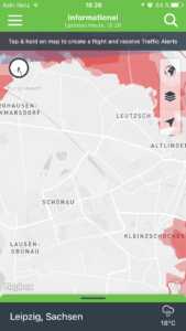
 Recommendation 3: myFly Zone
The last app in my referral list is myFly Zone, which was also developed for the German market.
The UI is rather simple and you expect fewer features in this drone app. You get a map with the airspace data. However, further information is missing, e.g. I miss weather data and also the display of the CP index.
When logbook, it is also not possible to provide information about the copter used, which bothers me personally very much. Of course, many drone pilots have multiple copters. For this, the name of the pilot can be specified via a free text. Instead of a free text, however, I would like a drop-down menu from which I can select previously defined pilots in order to be able to log flights faster on the way.
Advantages of myFly Zone:
- Clear presentation of the airspaces.
Disadvantages of myFly Zone:
- No information on the weather and the CP index.
- No contact details of airports and heliports.
- No administration of different drones in the logbook.
myFly Zone in the StoremyFly Zone app on Google Play
Now you know our recommendations for drone apps. Maybe you have already used it yourself? Then tell us in the comments of your experience with the respective apps. Do you also use other apps to prepare your Copter flights? We are curious! We are happy to include the best tips in this article.
Did you like the article? Then share it with your friends!
Hey! Nice that you pass us by. We are Bina & Francis – globetrotters, adventurers and drone freaks. Since January 2015 we travel with camera drone in the luggage around the world. We love to explore our Earth from a new perspective!
Follow our adventures
About the author
Hey, I’m Francis – globetrotter, blogger and drone pilot. Since January 2015 I travel around the world with Bina. Always in the luggage is a camera drone, with which we capture the most beautiful places from the air. On our blog we share with you the best tips for your next trip. Do you still have questions about this article? Then write us in the comments!
Learn more about this topic
Discussions on the topic
Hello Francis! Wanted to thank you for the good article and tips. I’ve downloaded the Kopter Pro app and am very happy with it
Hello Gerhard,
I’m glad, if the article helped you! Best regards, Francis
Can I only join Gerhard LG Hans
Very good information,
Thank you!
I can only join! thx
Hi,
I like to use the app hover for preparation and execution. Gibts for iOS and Android.
features:
– Airmap installed
– Flight logbook
– Weather and KP index
– News page (which I find superfluous)
– Timer
In addition, I also use map2fly (https://map2fly.flynex.de) There you can specifically for Germany (other countries I have not tried) quickly see the NSG and LSG areas, as well as roads and power lines. Airports and heliports and all that. Definitely worth a look.
Hello Willie,
Thank you for your comment. Hover was also the first app we used. The app did not work for a while, so I deleted it at some point. I’ll take a look at it on occasion.
Map2fly is really a cool application for flight preparation. Would be cool if they would bring out an app version.
Sunny greetings, Francis
is there a recommendation for 2019? Thank you
The contribution is still up to date;)
The DFS drones app should also be mentioned here. It takes all important laws into account in Germany and checks them off.
But it has to be greatly improved again. There are so many mistakes in it that can not be offered to a pilot with a clear conscience.
Hello Chris,
I see it like Willie. At the moment the DFS app is useless for me. I think it’s great that there is now official data. But yesterday I tried again to work with the app – this is not yet possible. As soon as there are improvements, I like to list the app.
Sunny greetings, Francis
I have also found a very good app that is very suitable for Germany. DFS drones shows exactly where you can fly and where not. On the other hand, you can keep a logbook and specify your drone. So everything you need and it is free
Hi Michael,
the app was not so good on my last test that I would have recommended it. I will take a closer look at them in the next few weeks. Thanks for your comment! Best regards, Francis
So regarding airspaces the dfs app is certainly unbeatable. It changes annually. And the dfs also issues the legally binding ICAO card for Germany. Of course, new every year.
DFS definitely has an excellent database;)
First of all, thanks for the tips, I downloaded Airmap, for example, and found out with my Huawie P20Lite that the remote control of the DJI Mavic Air is no longer communicating with the drone.
Without a mobile she flies, but I can not control what picture I’m doing.
I threw Airmap down again, then everything tutti.
Nevertheless, many thanks for the tips.
Hello Suzie,
I am hearing about this mistake for the first time. Very strange behavior. This is due to a wrong attitude, because now DJI drones can be controlled directly with the AirMap app. Maybe the hint will help.
LG Francis
I have general questions about airMap and would appreciate your support: It also runs offline?
Is it necessary to register / register in order to fully access Airmap??
Related Posts
-

Deposit: currently compare best deposit accounts, 11
fixed deposit With our fixed-term news, we keep you up to date. Regardless of whether changes in the law or interest rates, here you will learn…
-
Santanyí – abcmallorca experience mallorca from its best side
Santanyí Quiet and creative city in the southeast of Mallorca About Santanyí Santanyí is a municipality and a city in the southeast of the island – a…
-
Dji mavic air: all information about the new drone
DJI Mavic Air: All information about the new drone DJI presented its new drone, the DJI Mavic Air, on 23.01.2018. With the new model, the Chinese…
-

Cough suppressants: the best remedies that really help
Cough Remedies: The Best Remedies That Really Help What are the best cough suppressants and what really helps? In the cold season, strong defenses are…